- Remove Small landforms filter Small landforms
- Remove Voss, frå 2020 del av nye Voss herad. filter Voss, frå 2020 del av nye Voss herad.
- Remove Maritime environments filter Maritime environments
- Remove Seabirds filter Seabirds
- Remove Monastery filter Monastery
- Remove Fitjar filter Fitjar
- Remove Burial mounds filter Burial mounds
- Remove Faults filter Faults
- Remove Ullensvang, frå 2020 del av nye Ullensvang kommune. filter Ullensvang, frå 2020 del av nye Ullensvang kommune.
- Remove Tysnes filter Tysnes
- Remove Civil servant dwellings and manors filter Civil servant dwellings and manors

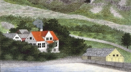
Fitjarøyane
If we study the group of islands south of Selbjørns Fjord from the air or on a sea map, we will notice that many of the islands are elongated and lie systematically in rows. The islands are divided by long sounds, for example Trollosen, Nuleia and Hjelmosen, which are oriented in a south-southeast to north-northwesterly direction.

Rimsvarden
Rimsvarden lies high and unencumbered, an enormous stone mound on the highest top with a wide view of the Fitjar rural community. With its 30 meters across and almost 4 meters high, this is one of the largest prehistoric burial relics existing in Hordaland.


Fluøyane
The richest seabird localities in Bjørna Fjord are FLUØYANE, a group of small and medium-sized islets just east of the entrance to Våge. Here, we see many different nesting birds, but there is the danger that overgrowth will become an obstacle for nesting here in the future. On one of the islands, the environmental protection authority has promised to step in and help the birds.

Årbakka- The prehistoric site
The prehistoric site at Årbakkasanden with menhirs and burial mounds has been visited, described and illustrated by many learned researchers through the last 350 years. All the same, we still know very little of this unique cultural monument.

Bordalsgjelet
Deep down between the stone polished phyllite bedrock in Bordalsgjelet canyon, there is a cascading river. In close cooperation with hard polishing stones, the water has carved into the bedrock for thousands of years - and is still doing so today.

Byrkjehaugen
On the farm Bø, close to the highway between Bulken and Voss lies Byrkjehaugen, one of the largest burial mounds in West Norway. Originally it was around 50m across and 5m high, but following the excavation in 1908 and chipping off by both railway and road construction, the cross-section has shrunk to 37m and the height to 4m. All the same, it is an impressive burial monument for the passing traveller to see.

Oppheim
In the slope above Oppheim church lies the old vicarage at OPPHEIM. If you stroll up the road from the church you will arrive in a farmyard marked by traces of building style and living traditions from the Middle Ages.
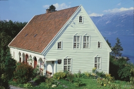
Helleland
The old “recorder residence” at Helleland has been both residence for the district recorder and officer’s residence. The main building, which came under protection in 1924, was built in 1764 by the curate Christian Heiberg. When he was appointed parish priest in Jølster, he sold the farm to the state employee Geelmuyden, who resold the farm to Hans De Knagenhielm in 1774. He was the head of “Søndre Hardangerske kompani” (a local army division).
Hesthamar
Hesthamar, some kilometres north of Utne, is one of the oldest residences for a district recorder in the country. In 1637, barely 50 years after the office of the district recorder was established in 1591, the local people bought this residence from the bailiff Lauritz Johnsen on Torsnes. From 1659 the district recorders lived here, intermittently, up to 1790. This is when Helleland at Lofthus became a “recorder” farm.

