- Remove Museums, nature conservation, cultural heritage filter Museums, nature conservation, cultural heritage
- Remove Arkeologi filter Arkeologi
- Remove Kvam filter Kvam
- Remove Place filter Place
- Remove Etne filter Etne
- Remove Osterøy filter Osterøy
- Remove Landscape filter Landscape
- Remove Archaeology filter Archaeology

Borgåsen
In Etne there are no less than four defensive refuges. They are all situated in strategic positions, so that they have served as places of refuge and protection for central parts of the district

Botnen
Fyksesundet and Botnagrenda present a fine experience of the landscape and cultural history; a geographically isolated local settlement with extensive cultural contact with the outside world.
Vangdal
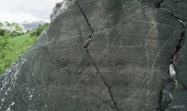
At Salthamaren in Vangdalsberget it is thought that salt was burned some time in history, and deep layers of coal in the ground show that fire has been made up here several times. But they were hardly salt-burners, the first people who stopped here. Some of them carved figures into the rock. On top of the rocky outcrop, furthest out on the cliff, a group of Stone Age hunters carved animal figures. More than 1,500 years later Bronze Age farmers drew ship figures at the foot of the rock. Both these works of art - some of the oldest in Hordaland – are still visible, carved in the rock at Salthamaren.

Etnedeltaet
During the latter half of the 1900s the big natural river deltas on Westland disappeared. Until the 1980s there was still a small, but significant remnant of the original river delta from the Etneelva river, but today most of this, too, is industrial land.

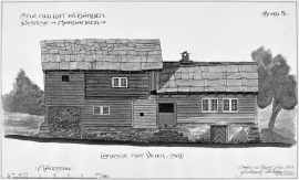
The village of Etne
Much of the sand and gravel that the town of Etne is built on was laid down at the end of the Ice Age and is evidence of melting glaciers and roaring meltwater rivers. The uncompacted material in the big terraces leave their unmistakeable mark on the wide elongated valleys.

Krokavatnet
On Sunday the 29th of January, 1989, at 17:38 o'clock, Etna shook. The earthquake, with its epicentre ca. 9 kilometres south of Etne centre, had a strength of 4.2 on the Richters scale. This could be felt over large parts of West Land, especially in the areas around Åkra, Etne, Hardanger Fjord and Sauda Fjord. The earthquake was the largest that has ever been measured in Hordaland.

Skånevik- moraine
In Skånevik there are marks left from the ice edge that advanced during the thousand-year cold spell (Younger Dryas) that marked the end of the Ice Age roughly 11 500 years ago. The glacier first proceeded out into Åkra Fjordand and around Vannes and thereafter sent an arm in toward Skånevik. Here, the glacier lay down an end moraine up against the mountainside.

Mosnes
The permanently-protected Mosneselva River, with its meltwater from Folgefonna, runs out into Åkra Fjord by the roadless and uninhabited Mosnes. Those who once lived here were forced to surrender to the ravages of Nature. In the autumn of 1962 there was a flood so great that the people were driven from their farms.


