- Remove Small landforms filter Small landforms
- Remove Tourism filter Tourism
- Remove Vegetation history filter Vegetation history
- Remove Conservation area filter Conservation area
- Remove Mineral resources filter Mineral resources


Langavassmyrane
The Ruff lek on Langvassmyrane is the only known phenomenon of its kind on Hardangervidda. Every year it attracts hens from the whole plateau. The marsh is also the richest wetland in the county. This green oasis is located in a rocky moraine landscape a few hours walking distance south of Dyranut.

Bjoreidalen
Bjoreidalen is one of the classic bird localities on Hardangervidda. It is especially known for its wading birds, with as many as 17 of the 19 wader species that nest in Hordaland.

Valldalen
Valldalen or Valdalen, the name that the locals used in past times, had been a permanent settlement for a long time, and later the biggest mountain-farm valley in western Norway. Since that time there have been many changes: Most of the fields are no longer in use. Bjørkeskogen, a birch forest that had grown in the valley for thousands of years, took more and more over. And in the valley bottom, the Valldals dam now keeps the artificially large Valldalsvatnet Lake in place.

Buardalen Valley
Buarbreen glacier was one of the first destinations during the period of increasing tourism in Odda in the 1800s. Foreigners came by the thousands, mostly Englishmen and Germans, to the magnificent landscape in front of the glacier. Back at the hotel in Odda they could enjoy drinks containing ice from the glacier.
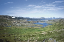
Veivatnet
From Kinsekvelven river and inward to Lake Veivatnet, we can wander through one of Hardangervidda's many fertile areas. A number of finicky plants grow here, and there are plenty of birds and fish. We can thank a lime rich soil for the diversity.


