- Remove Quarns and mills filter Quarns and mills
- Remove Civil servant dwellings and manors filter Civil servant dwellings and manors
- Remove Trading posts and guesthouses filter Trading posts and guesthouses
- Remove Austrheim filter Austrheim
- Remove Wetland filter Wetland
- Remove Stord filter Stord
- Remove Museum filter Museum
- Remove Igneous rocks filter Igneous rocks
- Remove Fitjar filter Fitjar

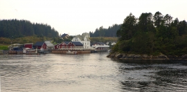
Engesund
For more than 350 years Engesund has been a place for hostelries and trading in the Fitjar islands. The place is centrally placed in the shipping lane, with a sheltered harbour close to the exposed Selbjørnsfjorden. Engesund was once part of the great network of historical stopover places on the coast.

Fitjarøyane
If we study the group of islands south of Selbjørns Fjord from the air or on a sea map, we will notice that many of the islands are elongated and lie systematically in rows. The islands are divided by long sounds, for example Trollosen, Nuleia and Hjelmosen, which are oriented in a south-southeast to north-northwesterly direction.

Færøysund
The old trading post lies at the sound between Stord and Færøy in Langenuen. There was a country store and steamship forwarding agent up to 1964. The trade was then moved over to the new ferry harbour of Sandvikvåg.


Kattnakken–Stovegolvet
The highest mountainous area on Stord, including Kattnakken, Midtfjellet and Stovegolvet, has more in common with the mountainous terrain on the mainland than in the low coastal landscape of Sunnhordland. The volcanic bedrock together with the erosive powers of nature has resulted in a unique plateau landscape.
Kjelstraumen
If you take the sea route north you have several options. The various routes have been dealt with in history, and through the Middle Ages the traffic increased as well as the trading with Nordland in fish and herring, feather and down. One of the central routes passes through Kjelstraumen, in the sound between Ulvøy and Bakkøy. This has been a place for a guesthouse since 1610, with Royal Letter of Privilege, part of the large network of trading post and guesthouse locations along the coast.


Leirvik- The trading post
Already in the Middle Ages the good harbour at Leirvik provided a connecting point. Here was a court of law, and a guesthouse was established here in the 1600s. But Leirvik never achieved the status of a trading post or a ship-loading place. In the census of 1865 parts of the farms Nordre Bjelland, Leirvik and Orninggård are mentioned as the “Coastal district of Lervig”. And the community grew around the old guesthouse location early in the 1800s.

