- Remove Arkeologi filter Arkeologi
- Remove Farm sites filter Farm sites
- Remove Livelihood and Craftsmanship filter Livelihood and Craftsmanship
- Remove Quarns and mills filter Quarns and mills
- Remove Vernacular crafts filter Vernacular crafts
- Remove Settlements, Villages, Towns filter Settlements, Villages, Towns
- Remove Museum filter Museum
- Remove Place filter Place

Aga
The grand farm Aga on the west side of Sørfjorden, came under protection in 1937, when the agricultural reform threatened to disperse the old clustered settlement. “Lagmannsstova”, named after the “lagmann” (law speaker) Sigurd Brynjulfsson, was already protected in 1924; one of the authentic profane wooden buildings from the Middle Ages still standing. All the same it is the farmyard itself that is the key cultural monument.


Arnatveit
On the farm of Arnatveit, high up on the slope above the highway, an old smokehouse remains standing in the courtyard of the main farm property, in the place of the old common courtyard. Today this farm lies at the outskirts of a large housing estate. Most of the farmland of the other farm properties has been sold to benefit the city’s need of sites for the new community of Arna.

Boga
In the lightly undulating landscape at Boga there lies an old house with several rooms on a small rise. In fact it looks like three houses built into one another; a scullery, a living room and a store with a loft. From other sources we know that this house had covered passageways and sheds round all the walls in the 19th century; a compressed “long house” with inter-connections between all the rooms. This is a building style from the Middle Ages that we see traces of; a building corresponding to those we have seen remains of at Høybøen in Fjell and Lurekalven in Lindås. Bogatunet was restored in 2006.


Bryggen
In the 1300s Bergen was a trading centre of European dimension. The town is thought to have had around 7000 inhabitants and was the largest and most important in the country. In a European context it was an average size town. At this time the most tightly built town area was still mostly east of Vågen from Holmen in the north to Vågsbotn in the south. Already in medieval times, latest in the 1340s, this area was called Bryggen.
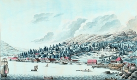
Damsgård
As a fairytale castle Damsgård Hovedgård lies on the slope rising up from the Puddefjord. The old connection between the farm and the sea, as we see it on Dreier’s prospectus from 1810, has been broken up by roads and encroachments in the building mass. But the main building itself is a central monument in Norwegian architecture from the 1700s – one of the finest representatives for the rococo period, with a magnificent and rich décor both in its interior and exterior.

Einstapevoll- the farm
Einstapevoll (from einstape: “bregne” (fern)) lies on the west side of the Tittelsnes peninsula. Up to 1831 the farm was a vicarage belonging to Stord parish. The priests had leasing rights. Land rent and other fees from the farm was part of their salaries.

Evanger
Evanger (from Old Norse ålvangr, “vang”, “voll” (field) where the horses may graze) is the place where the river from Vangsvatnet, the Voss watercourse, runs out into Evangervatnet. From here Teigdalen valley runs to the north, towards Eksingedalen, and from here there is a short distance to Bergsdalen in the south.

