- Remove Granvin, frå 2020 del av nye Voss herad filter Granvin, frå 2020 del av nye Voss herad
- Remove Osterøy filter Osterøy

Skjervet- river theft
At the end of the last ice age the ice flowed out of Hardanger fjord in such a fury that it forced the meltwater from Voss to run back uphill toward Granvin. The glacier from Raundalen down the windy valley along the Vosso to Bolstadøyri went too slow to make the turn.

Skjervet- road construction
The road between Eide in Granvin and Voss is one of the oldest roads mentioned in the Middle Ages. In a diploma from 1343 from Voss regarding distribution of road works, we also find mention of the road to Angr (the Granvin fjord).

Storegraven
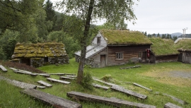
The first mention of Granvin church in written sources is in 1306, but the church location must be far older than this. The farm Storegraven is centrally situated at Granvinsvatnet, by the important traffic artery between Hardanger and Voss, where the road takes off to Ulvik.


Uranes
One of the most magnificent deciduous forests in Hordaland grows along the border with Kvam. The rich growth comes from the phyllite and mica schist bedrock, together with a good climate. Along the fjord the summer is warm but not too dry, and in winter it is not too cold for plants that do not tolerate the frost.


Hamre Church
Hamre Church has, by all accounts been one of the four main churches in Horda County in the Middle Ages. Hamre was a main church for the whole of Hordaland. Timber remains in the present church show that there was a stave church here in medieval times.


Herlandsnesjane
Herlandsnesjane, a four-kilometre long peninsula in Lake Storavatnet in the middle of Osterøy, is well known among botanists. Here lies an unusually large and diverse bog.

