- Remove Smallholdings filter Smallholdings
- Remove Place filter Place
- Remove Fisheries filter Fisheries
- Remove Churches filter Churches
- Remove Road constructions filter Road constructions
- Remove Igneous rocks filter Igneous rocks
- Remove Basement rocks filter Basement rocks
- Remove Metamorphic rocks filter Metamorphic rocks

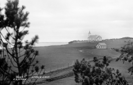
Herdla Church
A letter from the Pope Eugenius 3 in 1146 mentions St. Nikolaus church at Herdla. This church belonged under Munkeliv monastery, which was founded in Bergen by Øystein around 1110. The Herdla Church may stem from this time.
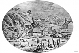
Strusshamn
On the south side of Askøy, just west of Bergen, lies Strusshamn. The sheltered bay is one of the best harbours in Byfjorden, on the route south. At the time of the sailing ships the harbour could be full of vessels from Bergen and abroad, lying in wait for favourable wind. Old anchoring rings from 1687 bear witness to this. Strusshamn was a quarantine harbour for ships that came sailing in with the yellow pest flag flying.


Haganes
The gneiss landscape west and north of Bergen viewed in profile can remind us of a saw blade of the kind that has long, slanted sides that get broken off shorter transverse sides. It has taken several hundred million years to file this saw blade, an enduring interplay between various geological processes.


Gullbotnen
A barren belt where almost nothing grows, runs through the forest on the east slope of Gullbotnen. But, along the west side of the main road there is a fertile zone that flourishes with several finicky plant types. The contrasts arise from the extreme variations in the nutrient content of the bedrock.


Ådland
Ådland, innermost in the Samnanger Fjord is an old church centre and transport centre; a nodal point in the transport from sea to land. The white painted church standing today, was built in 1851, but there were two older churches here in former centuries.

Golta- Gneiss
Over thousands of years, autumn storms and strong land-driving winds have cleaned the bare rocks of Golta. The waves can beat far in over land and make it dangerous to walk along the shoreline. When the storms have calmed, the results of their work comes into view.

