- Remove Arkeologi filter Arkeologi
- Remove Livelihood and Craftsmanship filter Livelihood and Craftsmanship
- Remove Sunnhordland filter Sunnhordland
- Remove Voss (tidl. kommune) filter Voss (tidl. kommune)
- Remove Landscape filter Landscape

Rekvesøyane
The sediment that was deposited from the river Dyrvo has created the fan-shaped delta Rekvesøyane. The bit of land farthest out toward the water gets periodically flooded, especially during snow melt and after periods of much rain.

Mosnes
The permanently-protected Mosneselva River, with its meltwater from Folgefonna, runs out into Åkra Fjord by the roadless and uninhabited Mosnes. Those who once lived here were forced to surrender to the ravages of Nature. In the autumn of 1962 there was a flood so great that the people were driven from their farms.

Melderskin
MELDERSKIN - ONCE A NUNATAK? Melderskin, the towering and majestic landmark at Rosendal, rises 1462 metres above sea level. The top area is smooth, but slightly inclined. Geologists think that the area is a remnant of a weakly undulating landscape, that originated near the sea, long before the Ice Age set in.


Krokavatnet
On Sunday the 29th of January, 1989, at 17:38 o'clock, Etna shook. The earthquake, with its epicentre ca. 9 kilometres south of Etne centre, had a strength of 4.2 on the Richters scale. This could be felt over large parts of West Land, especially in the areas around Åkra, Etne, Hardanger Fjord and Sauda Fjord. The earthquake was the largest that has ever been measured in Hordaland.
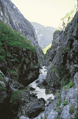
Jordalen
During the last ice ages, parts of the Voss river system were stolen and sent down Nærøydalen valley to Nærøy Fjord (Nærøyfjorden). Before this big river theft all of the rivers ran all the way from their sources in the mountains near the innermost part of the Sognefjord further southwards towards Voss. Evidence of the theft is still clearly visible in the terrain.

Huglo
The majority of Huglo is bare rock. A bit of dwarf pine forest is the only vegetation able to put down roots. Along the west- and east sides, to the contrary, the landscape is unusually green and lush. The reason lies both in the bedrock and in the ice that covered the area 12 000 years ago.

Halsnøy
Hadde ikkje Hardangerfjordbreen mot slutten av istida rykt fram over fjordbotnen, ville Halsnøy ikkje eksistert som éi øy, men som mange småøyar. Breen skuva framfor seg så mykje leire frå havbotnen at Brattåsen, Toftåsen, Landåsen og Svartaberg vart samla i eitt landområde.

