
Kjeåsen
High up above the fjord, at a height of 600m lie the two holdings at Kjeåsen. Today you can drive there by car, through a new tunnel that the power engineers in Sima have drilled. Until 1974 the only road went up the steep hillside, along iron bolted ladders across dizzying rocks – a road for the strong at heart.

Krækkjavassdraget
Few other animal species on Hardangervidda have been as much the focus of scientific research as the spotted trout. The spotted trout is considered to be a genetic variant of brown trout. It lives in parts of the Krækkjav water system. Otherwise, on a world scale, this species is only found in a small area in Kaukasus, and possibly also in a lake in Rondane.


Langavassmyrane
The Ruff lek on Langvassmyrane is the only known phenomenon of its kind on Hardangervidda. Every year it attracts hens from the whole plateau. The marsh is also the richest wetland in the county. This green oasis is located in a rocky moraine landscape a few hours walking distance south of Dyranut.

Måbø
Måbø is the uppermost farm in Måbødalen. This narrow and steep mountain valley has been one of the routes from the fjord communities up to the mountain plateau from times immemorial. We are not certain of the meaning of the name Måbø. Perhaps it has its origin in an Old Norse male name Mávi, from the name for seagull, már. The last syllable “bø” means farm. Today Måbø gives us a compact close-up of the subsistence economy: the small farm with the clearance piles, stone walls and a lane that guided the animals into the yard, at the foot of the great mountain expanse.

Måbødalen- geology
The old pack road had 1500 steps, where cars today gas through the mountain. The time of this hard work is over, and of getting used to the steep terrain, as well; only the view from the top is much the same as before. Vøringsfossen in summer is one of Western Norway’s biggest natural wonders. It marks the transition between the older, open part of the Sysendalen valley and the younger, narrow and winding valley of Måbødalen.


Simadalen
On the 10th of August, 1937, over half of the agricultural land in Simadalen was submerged by the river. The damage to roads and houses was also catastrophic. This was the most destructive flood ever recorded in Hordaland.
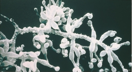
Skiftesjøen
A microscopic mushroom from Hardangervidda has been like a “golden hen” for the Swiss company Novartis. Everywhere in the world, companies are looking for genetic material from nature that can be used for developing new medicines. Occasionally they succeed.


