- Remove Quarns and mills filter Quarns and mills
- Remove Chieftains and royal lines filter Chieftains and royal lines
- Remove Vernacular arts filter Vernacular arts
- Remove Sediments filter Sediments
- Remove Railroad filter Railroad


Ulvik-village
The ice cap that covered the land during each of the 40 past ice ages over the past 2 million years of Earth's history pressed down the crust of the earth - like a finger on a rubber ball. And when the ice finally loosened its grip 11,000 years ago, the earth's crust rose again, most where the ice was thickest, least where it was thin, quickly in the beginning, and later more slowly. To this day, the land in the inner part of Norway continues to rise by perhaps one millimetre per year. By and large, however, the crust in Hordaland has again reached equilibrium after the weight of the ice was removed.

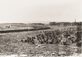
Herdla – glacial deposits
The shift in the landscape is striking between the barren craggy moors north on Askøy and the green fields of Herdla, which has the county's biggest farm. The majority of Herdla, such as the island appears today, is a gift from the glacier: The glacier that advanced here over 12,000 years ago stopped at the northern tip of Askøy and took its time building up the moraine on Herdla. Since then, Herdla has been under continual transformation. The re-organisation of the loose sediment deposits continues today.


Kvernapollen
When the workers came to Kollsnes to start on the work with the landing for the gas terminal from the Troll field in the North Sea, they found the ruins of an old farm mill at Kvernapollen.

Stormark
Both the climate and people have been decisive in shaping the bog landscape on Fedje - a landscape that has been evolving over several thousands of years. The peat got built up layer for layer and provided income and fuel for the people of Fedje.

Bjørsvik
The industrial settlement Bjørsvik

