- Remove Avalanches and rock falls filter Avalanches and rock falls
- Remove Faults filter Faults

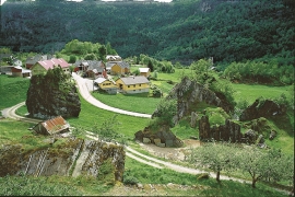
Bondhusdalen
The Bondhus area in Maruanger has been a magnet for tourists ever since the stream of tourists to Norway's west coast began in the middle of the 1800s. The magnificent landscape with the "ice trail" up to Bondhusvatnet Lake, the ice falls from Bondhusbreen glacier and Keisarstigen trail up to Folgefonna are still popular tourist attractions.

Fitjarøyane
If we study the group of islands south of Selbjørns Fjord from the air or on a sea map, we will notice that many of the islands are elongated and lie systematically in rows. The islands are divided by long sounds, for example Trollosen, Nuleia and Hjelmosen, which are oriented in a south-southeast to north-northwesterly direction.


Haganes
The gneiss landscape west and north of Bergen viewed in profile can remind us of a saw blade of the kind that has long, slanted sides that get broken off shorter transverse sides. It has taken several hundred million years to file this saw blade, an enduring interplay between various geological processes.

Kalvanes
On the 17th of January, 1993, the area between the towns of Odda and Eitrheimsneset were struck by a giant avalanche. One person was killed, and there was a lot of material damage.

Krokavatnet
On Sunday the 29th of January, 1989, at 17:38 o'clock, Etna shook. The earthquake, with its epicentre ca. 9 kilometres south of Etne centre, had a strength of 4.2 on the Richters scale. This could be felt over large parts of West Land, especially in the areas around Åkra, Etne, Hardanger Fjord and Sauda Fjord. The earthquake was the largest that has ever been measured in Hordaland.


Mundheim
At Mundheim there is a dangerous stretch of the highway. The mountainside has given way several times in this area. Typically, it happens in the spring, when the frost has loosened its grip.


