- Remove Cultural landscapes filter Cultural landscapes
- Remove Samnanger filter Samnanger
- Remove Voss, frå 2020 del av nye Voss herad. filter Voss, frå 2020 del av nye Voss herad.
- Remove Archaeological findings filter Archaeological findings
- Remove Chieftains and royal lines filter Chieftains and royal lines
- Remove Meland, frå 2020 del av nye Alver kommune. filter Meland, frå 2020 del av nye Alver kommune.
- Remove Hill forts filter Hill forts
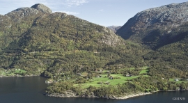
- Remove Jondal, frå 2020 del av nye Ullensvang kommune. filter Jondal, frå 2020 del av nye Ullensvang kommune.
- Remove Bergen filter Bergen
- Remove Tysnes filter Tysnes

Årstad
Alrekstad (later Årstad) is the birthplace of Bergen. The estate was an estate for Harald Hårfagre and several of his descendants: Eirik Blodøks, Håkon den gode og Olav Tryggvason. These first kings moved with their courts and guardsmen from estate to estate. From these estates the king ruled the country.
Torsnes
When bishop J.Neumann was on a visitation in Hardanger in 1825 he also visited Torsnes, the seat of the Galtung family. They were then in the process of pulling down the old dwelling house on the farm. As the committed observer of ancient monuments and antiquarian buildings that he was, bishop Neumann has provided us with interesting details:


Håøy
Håøy lies centrally in one of the main shipping lanes going into Bergen --- with Håyøsund on the south side facing Meland, and Hagelsundet facing Lindåslandet. Names like Nordfarskista and Nordfarsskorane explain things. The strategic position was important in Viking times and it has been important in our days too. The beacon on Håøy can have been built in the establishment of the coastal administration in Håkon the Good’s time, about 950 AD. The defence structure of which we say remains on Håøy Summit held a critical position during Norwegian neutrality during the First World War. The defence structure was taken down in 1957.

Husebø
When the Corncrake returned to Nordhordland, it came as no surprise that Husebø was the place it chose. Here, remnants of the old cultural landscape are still in good condition. And the Corncrake is not alone in appreciating this.


Ånuglo
Take a tour to Ånuglo on a warm summer's day. You can anchor up in Skipavågen and go exploring along the beach. Or, you can find giant holly trees and ivy inland on the island. If you take a trip to the small farms on the west side - one of which is still in operation - you can experience colourful flower meadows from a time most dream of, but few can still remember.

Byrkjehaugen
On the farm Bø, close to the highway between Bulken and Voss lies Byrkjehaugen, one of the largest burial mounds in West Norway. Originally it was around 50m across and 5m high, but following the excavation in 1908 and chipping off by both railway and road construction, the cross-section has shrunk to 37m and the height to 4m. All the same, it is an impressive burial monument for the passing traveller to see.

