- Remove Cultural landscapes filter Cultural landscapes
- Remove Ulvik filter Ulvik
- Remove Lakes, rivers and river networks filter Lakes, rivers and river networks
- Remove Austrheim filter Austrheim
- Remove Sedimentary rocks filter Sedimentary rocks
- Remove Fedje filter Fedje
- Remove Farm sites filter Farm sites

Frøystein
The farm Frøystein by the Ulvik fjord is commonly called Fryste. In 1614 the name was written Frøstemb – an obvious Danish influence – and the form Frøsten was used up until the land register in 1886 and 1907. It is probable that the name of the farm originally was Frystvin; a vin-name. Thus it has no connection with neither Frøy (Norse fertility god) nor stein (stone).

Osa
At the bottom of the Osa fjord there is a cultural landscape marked by great contrasts; the wide terraces and the river delta at the fjord contrast with the steep hillsides in the background, where Norddalen leads up to the mountain. There are two farms here. Osa and Sævartveit – the farm at the river mouth and the hollow by the sea.

Solskinstjørni
Solskinstjørni in Osa, just above Haugen farm in Norddalen, is visible only now and again, seemingly always for a period of good weather. Then it disappears abruptly, but its disappearance is not connected to weather conditions.

Trail toward Kyrkjedøri
Roughly 550 million years ago, what is now Finse lay at the bottom of the sea - the remains of mud and clay that were deposited in this sea have ended up on the roofs of Norway. Also the thrust sheet from the continental collision has found its way to Finse, after a several hundred kilometre-long, trek through the mountains, that took several tens of millions of years to complete.


Hopland
The farmhouses at holding No. 15 at Hopland are built together to form a long, continuous building, with dwelling house, hayshed and cowshed built in one row. There have been many such joined structures in the coastal communities, but today there are few remaining. If we travel to the other side of the North Sea, to the Faeroes, Shetland and the Orkney Islands, we find corresponding features in the older building traditions. We find ourselves in a large North Atlantic cultural area.


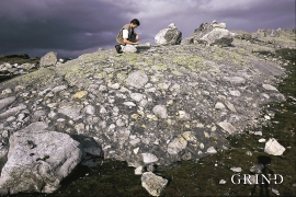
Holmengrå
Holmengrå is the only place in Hordaland where we find traces of the abrasion that is supposed to have transformed Western Norway from a Himalaya-like high mountain landscape during the earth's Paleozoic Era, to a flat lowlands terrain during the Mezosoic Era. Just 400 million years ago, large and small stones plummeted down from the high mountains. Some of these stones became incorporated into the conglomerate bedrock on Holmengrå.