- Remove Middle age filter Middle age
- Remove Amphibian filter Amphibian
- Remove Large landforms filter Large landforms
- Remove Conservation area filter Conservation area
- Remove Maritime environments filter Maritime environments
- Remove Place filter Place
- Remove Hardanger og Voss filter Hardanger og Voss
- Remove Boat- and shipyards filter Boat- and shipyards
- Remove Kvam filter Kvam
- Remove Runestones filter Runestones
- Remove Stone age filter Stone age
- Remove Ullensvang, frå 2020 del av nye Ullensvang kommune. filter Ullensvang, frå 2020 del av nye Ullensvang kommune.
- Remove Aristocracy and civil servants filter Aristocracy and civil servants
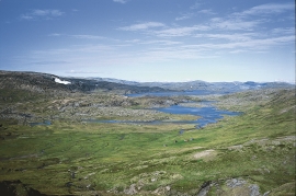
Veivatnet
From Kinsekvelven river and inward to Lake Veivatnet, we can wander through one of Hardangervidda's many fertile areas. A number of finicky plants grow here, and there are plenty of birds and fish. We can thank a lime rich soil for the diversity.
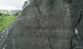
Vangdal
At Salthamaren in Vangdalsberget it is thought that salt was burned some time in history, and deep layers of coal in the ground show that fire has been made up here several times. But they were hardly salt-burners, the first people who stopped here. Some of them carved figures into the rock. On top of the rocky outcrop, furthest out on the cliff, a group of Stone Age hunters carved animal figures. More than 1,500 years later Bronze Age farmers drew ship figures at the foot of the rock. Both these works of art - some of the oldest in Hordaland – are still visible, carved in the rock at Salthamaren.

Ullensvang vicarage
Well over 200 years ago, the priest Niels Hertzberg started making climate observations at the vicarage at Lofthus in Ullensvang. Hertzberg was active and ahead of his time in many fields, and had a great interest in natural science. Temperature and pressure were measured daily at the vicarage - often several times a day - with homemade instruments. The meteorological measurements started in December of 1797, and were carried out continuously until 1840, the year before he died.

Tokagjelet
There is a sharp transition between the wide valley at Kvamskogen and the narrow Tokagjelet. The transition is no less dramatic when we come out of the crooked tunnels far down in the canyon, and the open Steinsdalen valley spreads out before us. The canyon both separates and joins together different epochs in western Norway's history.

Kinsarvik
Kinsarvik has probably been a centre for the inner Hardanger districts back in prehistory. History tells us that in medieval times there was a marketing place, a “kaupang”, here; a connecting point in the communications between east and west. There were supposedly around 300 residents here but the place was likely wiped out in a great fire.
Jåstad
The farm Jåstad, situated a few kilometres north of Agatunet, must have been a grand farm in medieval times. Torolf on Jåstad is mentioned as arbitration moderator in 1293, and in the vaulted corridor at Lyse Kloster Sigurd, farmer at Jåstad, and his wife Sigrid – the king’s kinswoman - are buried.

Hårteigen
Hårteigen, «the grey signpost», as the name suggests, is a landmark for mountain hikers on the western plateau. The piece of mountain is also a monument for the mighty rock layers that once covered the entire plateau.


