- Remove Maritime environments filter Maritime environments
- Remove Seabirds filter Seabirds
- Remove Monastery filter Monastery
- Remove Fitjar filter Fitjar
- Remove Ulvik filter Ulvik
- Remove Farm sites filter Farm sites
- Remove Odda, frå 2020 del av nye Ullensvang kommune. filter Odda, frå 2020 del av nye Ullensvang kommune.
- Remove Hydro power filter Hydro power
- Remove Sedimentary rocks filter Sedimentary rocks
- Remove Burial mounds filter Burial mounds

Frøystein
The farm Frøystein by the Ulvik fjord is commonly called Fryste. In 1614 the name was written Frøstemb – an obvious Danish influence – and the form Frøsten was used up until the land register in 1886 and 1907. It is probable that the name of the farm originally was Frystvin; a vin-name. Thus it has no connection with neither Frøy (Norse fertility god) nor stein (stone).


Trail toward Kyrkjedøri
Roughly 550 million years ago, what is now Finse lay at the bottom of the sea - the remains of mud and clay that were deposited in this sea have ended up on the roofs of Norway. Also the thrust sheet from the continental collision has found its way to Finse, after a several hundred kilometre-long, trek through the mountains, that took several tens of millions of years to complete.


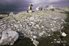
Rimsvarden
Rimsvarden lies high and unencumbered, an enormous stone mound on the highest top with a wide view of the Fitjar rural community. With its 30 meters across and almost 4 meters high, this is one of the largest prehistoric burial relics existing in Hordaland.


Årskog
Årskog farm is situated in a typical coastal landscape in a gentle terrain that slopes down from the outlying heaths down towards the fjord. The farm steading exists as it was in the 1800s. In 1980 the two brothers, Lars and Olai Årskog donated the farm with all its contents of tools and interior decoration, for museum purposes.

Reinsnos
The mountain settlement Reinsnos is situated at nearly 700 metres above sea level at the end of the Reinsnos lake; an entry point to the Hardanger plateau.
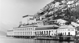
Tyssedal
Today Tyssedal appears like a classical industrial community, a picture of modern Norway from the turn of the former century until today. A/S Tyssefaldene was established in 1906, and on 1 May 1908 Tyssedal power station was put into operation. The work on the first stage of the facility was completed in a short time, with a work force of 500 men. They built water tunnels, regulation reservoirs, power station, penstocks, harbour, cableways, office buildings, houses and 6 km of power lines in the wild mountains above Odda to provide the new melting plant with power.