- Remove Quarns and mills filter Quarns and mills
- Remove Trading posts and guesthouses filter Trading posts and guesthouses
- Remove Railroad filter Railroad
- Remove Faults filter Faults
- Remove Ulvik filter Ulvik
- Remove Late glacial filter Late glacial
- Remove Fedje filter Fedje
- Remove Etne filter Etne

Bergensbanen
Already at the beginning of the 1870s demands were made that there had to be a railway connection between Bergen and East Norway. The first section between Bergen and Voss was finished in 1883. The route alternatives further on were many: Lærdal-Valdres, Aurland-Geiteryggen, Raundalen-Finse and Ulvik-Finse. Following a long dispute, an agreement was finally reached that the middle route alternative, Raundalen- Myrdal- Finse, was the best alternative. In 1894 the government passed a resolution that the Bergen railway should be built, but only the section Voss-Taugevatn. This was a political gamble in order to make the rest of the country participate in the plans. In 1898 it was approved that the railway be continued eastwards from Taugevatn to Oslo. This high mountain project was one of the most challenging railway projects in Europe. The Bergen railway was to be built across a mountain plateau without roads.

Bergensbanen- snow measurements
Opponents of the Bergen Railway used the snow argument for all it was worth. During the debate in Parliament before the decision about the route was reached in 1894, fears of snowfalls of over 20 metres were presented.

Rallarvegen
They rest there, all as one, the silent witnesses of Western Norway's saga of creation: Precambrian basement, phyllite and thrust sheet. In the end came the glaciers and sculptured the vast landscape. Along the ground or on the horizon, from bicycle or on foot - the landscape tells its story - and it tells it clearer on Rallarvegen than many other places.

Kræmmerholmen
Kræmmerholmen is one of the old privileged trading posts. From the 1600s all trading in West Norway took place in Bergen, and the farmers were obliged to travel into town in order to sell their produce and buy what they needed. In Bergen City Privilege of 1702 the merchants in the city were allowed to establish “Trading posts in the countryside”. The owner had to have residency in Bergen and the trading post was to be run by an assistant. In this way the city retained financial control of those living in the districts, and not least with buying and selling of fish.
Stormark
Both the climate and people have been decisive in shaping the bog landscape on Fedje - a landscape that has been evolving over several thousands of years. The peat got built up layer for layer and provided income and fuel for the people of Fedje.

The village of Etne
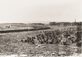
Much of the sand and gravel that the town of Etne is built on was laid down at the end of the Ice Age and is evidence of melting glaciers and roaring meltwater rivers. The uncompacted material in the big terraces leave their unmistakeable mark on the wide elongated valleys.
Kyrping
The trading post down by the fjord at Kyrping does not belong to the oldest group of trading posts from the 1600s and 1700s. It was only after the liberalisation of the trading legislation that trade was established here.
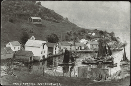
Skånevik- the trading post
There are only two buildings left of the old trading and guesthouse settlement in Skånevik. They are in the centre, close to the main road passing through the settlement. The other buildings that belonged to the place, the lodging house (“Holteriet”), the bakery, the courthouse, the boathouse and the sea house with the store, were pulled down in the last century.

Skånevik- moraine
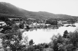
In Skånevik there are marks left from the ice edge that advanced during the thousand-year cold spell (Younger Dryas) that marked the end of the Ice Age roughly 11 500 years ago. The glacier first proceeded out into Åkra Fjordand and around Vannes and thereafter sent an arm in toward Skånevik. Here, the glacier lay down an end moraine up against the mountainside.

Krokavatnet
On Sunday the 29th of January, 1989, at 17:38 o'clock, Etna shook. The earthquake, with its epicentre ca. 9 kilometres south of Etne centre, had a strength of 4.2 on the Richters scale. This could be felt over large parts of West Land, especially in the areas around Åkra, Etne, Hardanger Fjord and Sauda Fjord. The earthquake was the largest that has ever been measured in Hordaland.

