- Remove Smallholdings filter Smallholdings
- Remove Civil servant dwellings and manors filter Civil servant dwellings and manors
- Remove Etne filter Etne
- Remove Trading posts and guesthouses filter Trading posts and guesthouses
- Remove Sveio filter Sveio
- Remove Rock carvings filter Rock carvings
- Remove Wetland filter Wetland
- Remove Late glacial filter Late glacial

The village of Etne
Much of the sand and gravel that the town of Etne is built on was laid down at the end of the Ice Age and is evidence of melting glaciers and roaring meltwater rivers. The uncompacted material in the big terraces leave their unmistakeable mark on the wide elongated valleys.

Etnedeltaet
During the latter half of the 1900s the big natural river deltas on Westland disappeared. Until the 1980s there was still a small, but significant remnant of the original river delta from the Etneelva river, but today most of this, too, is industrial land.

Helgaberget
Helgaberget – the holy hill – is a little rocky crag which thrusts itself a few metres above the terraced surface of Støle. The surface of the rock is strewn with figures inscribed in the rock and it was, as far as one can judge, a cult centre in the Bronze Ages. The name could indicate that the tradition of holiness can have lasted for almost 3,000 years.
Kyrping
The trading post down by the fjord at Kyrping does not belong to the oldest group of trading posts from the 1600s and 1700s. It was only after the liberalisation of the trading legislation that trade was established here.
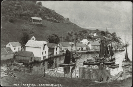
Skånevik- the trading post
There are only two buildings left of the old trading and guesthouse settlement in Skånevik. They are in the centre, close to the main road passing through the settlement. The other buildings that belonged to the place, the lodging house (“Holteriet”), the bakery, the courthouse, the boathouse and the sea house with the store, were pulled down in the last century.

Einstapevoll- the farm
Einstapevoll (from einstape: “bregne” (fern)) lies on the west side of the Tittelsnes peninsula. Up to 1831 the farm was a vicarage belonging to Stord parish. The priests had leasing rights. Land rent and other fees from the farm was part of their salaries.

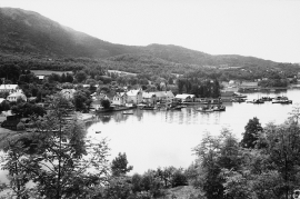
Skånevik- moraine
In Skånevik there are marks left from the ice edge that advanced during the thousand-year cold spell (Younger Dryas) that marked the end of the Ice Age roughly 11 500 years ago. The glacier first proceeded out into Åkra Fjordand and around Vannes and thereafter sent an arm in toward Skånevik. Here, the glacier lay down an end moraine up against the mountainside.


Bjellandsvatnet
Lake Bjellandsvatnet is one of the richest wetland areas in Sveio. But, everything has its limit, and the supply of nutrients can be too much. This is what was about to happen in Lake Bjellandsvatnet.


