- Remove Small landforms filter Small landforms
- Remove Cultural landscapes filter Cultural landscapes
- Remove Ulvik filter Ulvik
- Remove Kvam filter Kvam
- Remove Lindås, frå 2020 del av nye Alver kommune. filter Lindås, frå 2020 del av nye Alver kommune.
- Remove Trading posts and guesthouses filter Trading posts and guesthouses
- Remove Stord filter Stord
- Remove Faults filter Faults
- Remove Late glacial filter Late glacial


Botnen
Fyksesundet and Botnagrenda present a fine experience of the landscape and cultural history; a geographically isolated local settlement with extensive cultural contact with the outside world.

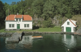
Bru
Bruosen is one of the few river harbours in the county. As landing place for the churchgoers, this place and the boatshed environment follow a tradition that goes back to the Middle Ages, but the country store of today is much younger.
Bruknappen
The hostelry place in Bruknappen is situated north in Radsundet, just south of Festo, by a sheltered idyllic bay, close to the main lane. Sloops both from Sognefjorden and Nordland had their fixed stops at “the blacksmith in Bruknappen”; on their way to Bergen, fully loaded with wood and hazel hoops, barrels and chests, or on their way home with town merchandise.

Huglo
The majority of Huglo is bare rock. A bit of dwarf pine forest is the only vegetation able to put down roots. Along the west- and east sides, to the contrary, the landscape is unusually green and lush. The reason lies both in the bedrock and in the ice that covered the area 12 000 years ago.

Hystad- the black alder forest
One of the biggest black alder forests in the country is in Hystadmarkjo. Along the well prepared trail through the forest you can experience an exceptional nature with an unusual abundance of exuberant plant species. But what has laid the foundation for this richness?


Jomfrunuten
Freezing and thawing are processes that influence plant cover, move enormous blocks, stretche long mounds of earth, break open bedrock and create patterns in stone and earth.

Leirvik- The trading post
Already in the Middle Ages the good harbour at Leirvik provided a connecting point. Here was a court of law, and a guesthouse was established here in the 1600s. But Leirvik never achieved the status of a trading post or a ship-loading place. In the census of 1865 parts of the farms Nordre Bjelland, Leirvik and Orninggård are mentioned as the “Coastal district of Lervig”. And the community grew around the old guesthouse location early in the 1800s.

Lurekalven
Lurekalven is an unpopulated island of heather moor which is a part of the wilderness belonging to the five farms on Ytre Lygra. Between the two islands there is only a small sound. As late as the 1920s, milking cows were rowed over the sound from Lygra in summer – a form of farming that was adapted to the coastal landscape.

