- Remove Small landforms filter Small landforms
- Remove Cultural landscapes filter Cultural landscapes
- Remove Ulvik filter Ulvik
- Remove Kvam filter Kvam
- Remove Lindås, frå 2020 del av nye Alver kommune. filter Lindås, frå 2020 del av nye Alver kommune.
- Remove Sedimentary rocks filter Sedimentary rocks
- Remove Amphibian filter Amphibian
- Remove Basement rocks filter Basement rocks
- Remove Trading posts and guesthouses filter Trading posts and guesthouses


Botnen
Fyksesundet and Botnagrenda present a fine experience of the landscape and cultural history; a geographically isolated local settlement with extensive cultural contact with the outside world.

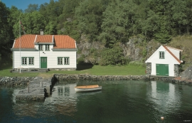
Bru
Bruosen is one of the few river harbours in the county. As landing place for the churchgoers, this place and the boatshed environment follow a tradition that goes back to the Middle Ages, but the country store of today is much younger.
Bruknappen
The hostelry place in Bruknappen is situated north in Radsundet, just south of Festo, by a sheltered idyllic bay, close to the main lane. Sloops both from Sognefjorden and Nordland had their fixed stops at “the blacksmith in Bruknappen”; on their way to Bergen, fully loaded with wood and hazel hoops, barrels and chests, or on their way home with town merchandise.

Geitaknottane
Many travellers between Mundheim and Gjermundshamn are captivated by the expansive view toward Øynefjord, Varaldsøy and Folgefonna. The barren pine forest on the slopes on the upper-side of the road is not seen by many. Who would think that this area is home to rare species of plants and animals, creatures who have made their homes here for thousands of years?


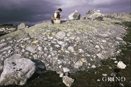
Jomfrunuten
Freezing and thawing are processes that influence plant cover, move enormous blocks, stretche long mounds of earth, break open bedrock and create patterns in stone and earth.

Lurekalven
Lurekalven is an unpopulated island of heather moor which is a part of the wilderness belonging to the five farms on Ytre Lygra. Between the two islands there is only a small sound. As late as the 1920s, milking cows were rowed over the sound from Lygra in summer – a form of farming that was adapted to the coastal landscape.

Lygra
The heath landscape on outer Lygra, Utluro and Lurekalven will in future become part of a landscape protection area, to be maintained through traditional activities with year-round outdoor sheep, grazing and burning. The West Norwegian heath country belongs to a large North Atlantic coastal landscape stretching from the Bay of Biscay to the Lofoten islands.

