- Remove Small landforms filter Small landforms
- Remove Conservation area filter Conservation area
- Remove Late glacial filter Late glacial
- Remove Glaciers filter Glaciers
- Remove Lichens, mosses, fungi filter Lichens, mosses, fungi
- Remove Hardanger og Voss filter Hardanger og Voss

Folgefonna
The glacier is not only white – it is full of colour. The colours have several sources: glacial flour, desert dust, or living algae. And the light refraction in the ice creates cool, bluish nuances – a masterpiece of the interaction between cold and light.


Bjoreidalen
Bjoreidalen is one of the classic bird localities on Hardangervidda. It is especially known for its wading birds, with as many as 17 of the 19 wader species that nest in Hordaland.

Fruo
At Fruo, nature has built its own little "Chinese wall ". Some kilometers south of the Vøringsfossen waterfall, there are a number of moraine ridges, the longest and most notable of their kind in Hordaland.

Hæreid- geology
The Eidfjord terrace is a gigantic ridge that reaches up more than one hundred metres from the city centre in Eidfjord. It serves as a powerful natural monument left behind by the ice when it retreated.


Langavassmyrane
The Ruff lek on Langvassmyrane is the only known phenomenon of its kind on Hardangervidda. Every year it attracts hens from the whole plateau. The marsh is also the richest wetland in the county. This green oasis is located in a rocky moraine landscape a few hours walking distance south of Dyranut.

Simadalen
On the 10th of August, 1937, over half of the agricultural land in Simadalen was submerged by the river. The damage to roads and houses was also catastrophic. This was the most destructive flood ever recorded in Hordaland.
Skiftesjøen
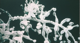
A microscopic mushroom from Hardangervidda has been like a “golden hen” for the Swiss company Novartis. Everywhere in the world, companies are looking for genetic material from nature that can be used for developing new medicines. Occasionally they succeed.

Granvinsvassdraget
After the ice age, Granvin Fjord reached all the way up under Skjervsfjossen waterfall. Just a thousand years later, as a result of the rising of the land after the ice melted, this whole inner part of the fjord freed itself of the sea and became Granvinsvatnet lake. In spite of this rise in elevation, this waterway is still navigable for fish: Sea trout have wandered into Granvinsvatnet in more recent times and evolved to become freshwater trout. And salmon and sea trout made the journey 13 kilometres up the Storelvi river.

