- Remove Small landforms filter Small landforms
- Remove Lakes, rivers and river networks filter Lakes, rivers and river networks
- Remove Voss, frå 2020 del av nye Voss herad. filter Voss, frå 2020 del av nye Voss herad.
- Remove Conservation area filter Conservation area
- Remove Rock carvings filter Rock carvings
- Remove Avalanches and rock falls filter Avalanches and rock falls
- Remove Etne filter Etne
- Remove Waterfalls filter Waterfalls

Etne river
There is still life to be found that is just “hanging on a string”. The Etne river has been the most important river for sports- fisherman in Hordaland after salmon fishing in Vosso was temporarily forbidden. As late as 2000, 4 tonnes of salmon and sea trout were taken out of the Etne river, the best fishing for 10 years. In the whole of the county there are only 15-20 rivers that can compete with this haul.

Helgaberget
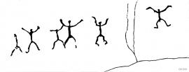
Helgaberget – the holy hill – is a little rocky crag which thrusts itself a few metres above the terraced surface of Støle. The surface of the rock is strewn with figures inscribed in the rock and it was, as far as one can judge, a cult centre in the Bronze Ages. The name could indicate that the tradition of holiness can have lasted for almost 3,000 years.


Bordalsgjelet
Deep down between the stone polished phyllite bedrock in Bordalsgjelet canyon, there is a cascading river. In close cooperation with hard polishing stones, the water has carved into the bedrock for thousands of years - and is still doing so today.


Lønaøyane
The Strandaelvi river is forever protected from the development of hydropower. The Lønaøyane islands – which comprise the delta furthest north in Lake Lønavatnet - are a part of this water system. In 1995 the level of protection for the Lønaøyne islands was strengthened to that of a nature preserve because of the rich birdlife in this wetland.

Rekvesøyane
The sediment that was deposited from the river Dyrvo has created the fan-shaped delta Rekvesøyane. The bit of land farthest out toward the water gets periodically flooded, especially during snow melt and after periods of much rain.