- Remove Small landforms filter Small landforms
- Remove Deciduous forests filter Deciduous forests
- Remove Askøy filter Askøy
- Remove Coniferous forests filter Coniferous forests
- Remove Maritime environments filter Maritime environments
- Remove Seabirds filter Seabirds
- Remove Monastery filter Monastery
- Remove Fitjar filter Fitjar
- Remove Avalanches and rock falls filter Avalanches and rock falls
- Remove Etne filter Etne
- Remove Igneous rocks filter Igneous rocks
- Remove Stord filter Stord
- Remove Runestones filter Runestones
Herdleflaket
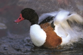
Spring, summer and autumn, there is bird life on Valen, and the tidal zone is especially attractive. Out on Herdlaflaket, you see ducks and other diving birds all year round, but most in winter.

Grindheim church
The first church at Grindheim was a stave church with a free-standing steeple. The church was first mentioned in 1326, but was probably built long before this time.


Stordalen
When the Etne water system was protected in 1994, preservation of the cultural landscape in Stordalen Valley was a a main objective. This is a valley with an exceptional abundance of Different types of plants and animals. In the grey alder forest in Stordalen there are more bird species than in most other places, in fact, denser than one tends to find in a tropical rainforest.

Fitjarøyane
If we study the group of islands south of Selbjørns Fjord from the air or on a sea map, we will notice that many of the islands are elongated and lie systematically in rows. The islands are divided by long sounds, for example Trollosen, Nuleia and Hjelmosen, which are oriented in a south-southeast to north-northwesterly direction.


Hystad- the black alder forest
One of the biggest black alder forests in the country is in Hystadmarkjo. Along the well prepared trail through the forest you can experience an exceptional nature with an unusual abundance of exuberant plant species. But what has laid the foundation for this richness?

Kattnakken–Stovegolvet
The highest mountainous area on Stord, including Kattnakken, Midtfjellet and Stovegolvet, has more in common with the mountainous terrain on the mainland than in the low coastal landscape of Sunnhordland. The volcanic bedrock together with the erosive powers of nature has resulted in a unique plateau landscape.

