- Remove Small landforms filter Small landforms
- Remove Austevoll filter Austevoll
- Remove Delta filter Delta
- Remove Maritime environments filter Maritime environments
- Remove Seabirds filter Seabirds
- Remove Monastery filter Monastery
- Remove Fitjar filter Fitjar
- Remove Avalanches and rock falls filter Avalanches and rock falls
- Remove Etne filter Etne
- Remove Sund, frå 2020 del av nye Øygarden kommune filter Sund, frå 2020 del av nye Øygarden kommune
- Remove Churches filter Churches
- Remove Coniferous forests filter Coniferous forests

Goltasundet
For generations the land-seine was the most important tool for catching herring and mackerel, and therefore a suitable casting bay was worth its weight in gold. Goltasundet (the Golta sound) on Golta was such a place. Here the herring often drifted in and fantastic casts might be made here.


Tyssøy
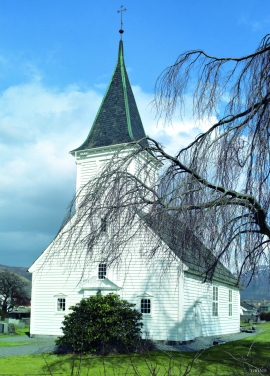
B.E.Bendixen, who has written about “The Churches in Søndre Bergenhus Amt”, believed even around 1900 that there was evidence at Tyssøy of the church or the chapel of the Holy Ludvig (Louis). Two large stone blocks had lain in the western wall of the church’s nave, and this wall showed a length of 16 meters in the terrain.
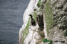
Møkster- seabirds
Fish and guests smell after three days, it is said. The cormorants do not need this long. If you follow your nose, the cormorant is not difficult to find.


Mosnes
The permanently-protected Mosneselva River, with its meltwater from Folgefonna, runs out into Åkra Fjord by the roadless and uninhabited Mosnes. Those who once lived here were forced to surrender to the ravages of Nature. In the autumn of 1962 there was a flood so great that the people were driven from their farms.

Etnedeltaet
During the latter half of the 1900s the big natural river deltas on Westland disappeared. Until the 1980s there was still a small, but significant remnant of the original river delta from the Etneelva river, but today most of this, too, is industrial land.

