- Remove Small landforms filter Small landforms
- Remove Maritime environments filter Maritime environments
- Remove Seabirds filter Seabirds
- Remove Monastery filter Monastery
- Remove Fitjar filter Fitjar
- Remove Ullensvang, frå 2020 del av nye Ullensvang kommune. filter Ullensvang, frå 2020 del av nye Ullensvang kommune.
- Remove Middle age filter Middle age
- Remove Large landforms filter Large landforms
- Remove Sediments filter Sediments
- Remove Iron age filter Iron age

Fitjar- the King's farm
In front of Fitjar Church there is a memorial stone, sculpted by Anne Grimdalen and erected in 1961, for the thousand-year memorial of one of the most dramatic events in Norway’s history, the Battle of Fitjar. This was the place where Norway’s king, Håkon the Good, suffered his fatal injury in the fight with Eirik’s sons, probably in the year 961.

Aga
The grand farm Aga on the west side of Sørfjorden, came under protection in 1937, when the agricultural reform threatened to disperse the old clustered settlement. “Lagmannsstova”, named after the “lagmann” (law speaker) Sigurd Brynjulfsson, was already protected in 1924; one of the authentic profane wooden buildings from the Middle Ages still standing. All the same it is the farmyard itself that is the key cultural monument.
Jåstad
The farm Jåstad, situated a few kilometres north of Agatunet, must have been a grand farm in medieval times. Torolf on Jåstad is mentioned as arbitration moderator in 1293, and in the vaulted corridor at Lyse Kloster Sigurd, farmer at Jåstad, and his wife Sigrid – the king’s kinswoman - are buried.

Ullensvang church
Ullensvang church, situated beside the vicarage, in idyllic surroundings on the headland just inside Lofthus municipality, is mentioned for the first time in written sources in 1309. At that time the present Gothic stone church must have been new. Judging by the style in the western portal and the eastern chancel windows, the church must have been built around 1300 or just before, probably by builders from Bergen influenced by the English Gothic style.


Fitjarøyane
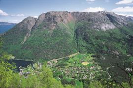
If we study the group of islands south of Selbjørns Fjord from the air or on a sea map, we will notice that many of the islands are elongated and lie systematically in rows. The islands are divided by long sounds, for example Trollosen, Nuleia and Hjelmosen, which are oriented in a south-southeast to north-northwesterly direction.

Fitjar- potatoes
The deep agricultural soils in Fitjar are found especially in the area between Lake Storavatnet and Breivika. The many stonewalls in the area reflect that the earth probably was full of stones and stone blocks. The stones that couldn't be dug out had also a function: they stored heat that helped to grow potatoes.