- Remove Smallholdings filter Smallholdings
- Remove Vernacular crafts filter Vernacular crafts
- Remove Railroad filter Railroad
- Remove Late glacial filter Late glacial
- Remove Defense filter Defense
- Remove Faults filter Faults


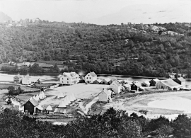
Osøyro
The coastal settlement of Os begins to take form in the middle of the 1800s. This is when craftsmen and traders begin to settle at the river delta.


Skånevik- moraine
In Skånevik there are marks left from the ice edge that advanced during the thousand-year cold spell (Younger Dryas) that marked the end of the Ice Age roughly 11 500 years ago. The glacier first proceeded out into Åkra Fjordand and around Vannes and thereafter sent an arm in toward Skånevik. Here, the glacier lay down an end moraine up against the mountainside.

Krokavatnet
On Sunday the 29th of January, 1989, at 17:38 o'clock, Etna shook. The earthquake, with its epicentre ca. 9 kilometres south of Etne centre, had a strength of 4.2 on the Richters scale. This could be felt over large parts of West Land, especially in the areas around Åkra, Etne, Hardanger Fjord and Sauda Fjord. The earthquake was the largest that has ever been measured in Hordaland.


