- Remove Smallholdings filter Smallholdings
- Remove Civil servant dwellings and manors filter Civil servant dwellings and manors
- Remove Waterfalls filter Waterfalls
- Remove Monastery filter Monastery
- Remove Fisheries filter Fisheries
- Remove Chieftains and royal lines filter Chieftains and royal lines


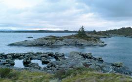
Fossen Bratte
The steep drop by Fossen cliff has been the biggest challenge for those who wished to make a road over Kvamskogen through the years. Leave the car by the monument on the old road and take a walk down to the bend by the waterfall that Bergen-folk call "The bridal veil". Why is there a waterfall just here?

Goltasundet
For generations the land-seine was the most important tool for catching herring and mackerel, and therefore a suitable casting bay was worth its weight in gold. Goltasundet (the Golta sound) on Golta was such a place. Here the herring often drifted in and fantastic casts might be made here.

Skogsvåg
Kval i våg! Når det ropet gjekk, var det berre å få ut den kraftige kvalnota til å stengja vågen med, og så kunne veidinga ta til. I uminnelege tider har det vore drive kvalveiding i Skogsvågen.


Seim
Sæheim (Seim) at Lygrefjord is mentioned as one of the royal farms of Harald Hårfagre. Several of the first Norwegian national kings had their seat here, and the farm became Crown Property up to the 1400s. According to the sagas, Håkon den gode is buried on the farm.

Frekhaug
Frekhaug has been a large farm with well-off owners through many generations. The main house, a two storey building with a hipped roof, must have been erected about 1780.

Håøy
Håøy lies centrally in one of the main shipping lanes going into Bergen --- with Håyøsund on the south side facing Meland, and Hagelsundet facing Lindåslandet. Names like Nordfarskista and Nordfarsskorane explain things. The strategic position was important in Viking times and it has been important in our days too. The beacon on Håøy can have been built in the establishment of the coastal administration in Håkon the Good’s time, about 950 AD. The defence structure of which we say remains on Håøy Summit held a critical position during Norwegian neutrality during the First World War. The defence structure was taken down in 1957.

Fosnstraumen
At the southern end of the bridge between Radøy and Fosnøy archaeologists found an unusual Stone Age settlement. There was a thick “cultural layer” here with the remains of the waste dumps of a hunting people. The place was called Kotedalen. Here they came, one group after the other, and settled for some weeks, some months, or maybe years before they went on, leaving the settlement deserted. Time after time it happened. At least 16 settlement phases have been identified, stretching over 5,500 years.

