- Remove Place filter Place
- Remove Ulvik filter Ulvik
- Remove Voss, frå 2020 del av nye Voss herad. filter Voss, frå 2020 del av nye Voss herad.
- Remove Fedje filter Fedje
- Remove Fjell, frå 2020 del av nye Øygarden kommune filter Fjell, frå 2020 del av nye Øygarden kommune
- Remove Landscape filter Landscape

Jomfrunuten
Freezing and thawing are processes that influence plant cover, move enormous blocks, stretche long mounds of earth, break open bedrock and create patterns in stone and earth.

Osa
At the bottom of the Osa fjord there is a cultural landscape marked by great contrasts; the wide terraces and the river delta at the fjord contrast with the steep hillsides in the background, where Norddalen leads up to the mountain. There are two farms here. Osa and Sævartveit – the farm at the river mouth and the hollow by the sea.

Rallarvegen
They rest there, all as one, the silent witnesses of Western Norway's saga of creation: Precambrian basement, phyllite and thrust sheet. In the end came the glaciers and sculptured the vast landscape. Along the ground or on the horizon, from bicycle or on foot - the landscape tells its story - and it tells it clearer on Rallarvegen than many other places.

Ulvik-village
The ice cap that covered the land during each of the 40 past ice ages over the past 2 million years of Earth's history pressed down the crust of the earth - like a finger on a rubber ball. And when the ice finally loosened its grip 11,000 years ago, the earth's crust rose again, most where the ice was thickest, least where it was thin, quickly in the beginning, and later more slowly. To this day, the land in the inner part of Norway continues to rise by perhaps one millimetre per year. By and large, however, the crust in Hordaland has again reached equilibrium after the weight of the ice was removed.

Fjell river network
There are many river networks out by the coast and they tend to be small and unassuming. The farmer has relied upon the watercourses to run his mill and saw, and it may be that the trout have given him a good source of food in years when the ocean fish failed. In our time, these river networks are being rediscovered for their value in recreation and outdoor life, and several places, tourist trails have been built in order to fully enjoy them.

Haganes
The gneiss landscape west and north of Bergen viewed in profile can remind us of a saw blade of the kind that has long, slanted sides that get broken off shorter transverse sides. It has taken several hundred million years to file this saw blade, an enduring interplay between various geological processes.

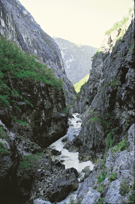
Bordalsgjelet
Deep down between the stone polished phyllite bedrock in Bordalsgjelet canyon, there is a cascading river. In close cooperation with hard polishing stones, the water has carved into the bedrock for thousands of years - and is still doing so today.

Jordalen
During the last ice ages, parts of the Voss river system were stolen and sent down Nærøydalen valley to Nærøy Fjord (Nærøyfjorden). Before this big river theft all of the rivers ran all the way from their sources in the mountains near the innermost part of the Sognefjord further southwards towards Voss. Evidence of the theft is still clearly visible in the terrain.

Rekvesøyane
The sediment that was deposited from the river Dyrvo has created the fan-shaped delta Rekvesøyane. The bit of land farthest out toward the water gets periodically flooded, especially during snow melt and after periods of much rain.

