- Remove Quarns and mills filter Quarns and mills
- Remove Hydro power filter Hydro power
- Remove Mountain plants filter Mountain plants
- Remove Wetland filter Wetland
- Remove Sediments filter Sediments
- Remove Place filter Place
- Remove Hardanger og Voss filter Hardanger og Voss
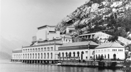
Tyssedal
Today Tyssedal appears like a classical industrial community, a picture of modern Norway from the turn of the former century until today. A/S Tyssefaldene was established in 1906, and on 1 May 1908 Tyssedal power station was put into operation. The work on the first stage of the facility was completed in a short time, with a work force of 500 men. They built water tunnels, regulation reservoirs, power station, penstocks, harbour, cableways, office buildings, houses and 6 km of power lines in the wild mountains above Odda to provide the new melting plant with power.

Jonstein
When high school student Arne Handegard collected plants for a herbarium in 1962, he didn’t know what kind of rarity he had pressed into his notebook. 30 years later he attended a botanical lecture, where a picture was shown of a plant he recognized: “Norwegian Sagebrush, which in Norway is only found in a large area of Dovre and in Trollheimen, and in a little area in Ry county”. Arne Handegard raised his hand: “That plant grows on Mt. Jonstein in Jondal”.

Fruo
At Fruo, nature has built its own little "Chinese wall ". Some kilometers south of the Vøringsfossen waterfall, there are a number of moraine ridges, the longest and most notable of their kind in Hordaland.

Hæreid- geology
The Eidfjord terrace is a gigantic ridge that reaches up more than one hundred metres from the city centre in Eidfjord. It serves as a powerful natural monument left behind by the ice when it retreated.


Langavassmyrane
The Ruff lek on Langvassmyrane is the only known phenomenon of its kind on Hardangervidda. Every year it attracts hens from the whole plateau. The marsh is also the richest wetland in the county. This green oasis is located in a rocky moraine landscape a few hours walking distance south of Dyranut.


Granvinsvassdraget
After the ice age, Granvin Fjord reached all the way up under Skjervsfjossen waterfall. Just a thousand years later, as a result of the rising of the land after the ice melted, this whole inner part of the fjord freed itself of the sea and became Granvinsvatnet lake. In spite of this rise in elevation, this waterway is still navigable for fish: Sea trout have wandered into Granvinsvatnet in more recent times and evolved to become freshwater trout. And salmon and sea trout made the journey 13 kilometres up the Storelvi river.
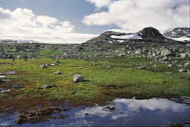
Finse
Many mountain plants are well prepared to face cold and wind. Some would surely rather face an easier life in the lowlands, but they cannot compete with the higher-growing plants living there. Most mountain plants manage to compete for light and space only if they cling to the bedrock and gravel in the harsh high alpine climate.

Rallarvegen
They rest there, all as one, the silent witnesses of Western Norway's saga of creation: Precambrian basement, phyllite and thrust sheet. In the end came the glaciers and sculptured the vast landscape. Along the ground or on the horizon, from bicycle or on foot - the landscape tells its story - and it tells it clearer on Rallarvegen than many other places.

